

Plat of Topography / Topographic Survey
Plat of Topography / Topographic Survey
- A topographic survey is the delineation of horizontal and/or vertical locations of the existing natural or man-made features of a portion of the earth’s surface, subsurface or airspace and the graphic representation of the results of such delineation. Topographic surveys that also depict land boundaries shall be entitled “Boundary and Topographic Survey” or “ALTA/ACSM Land Title and Topographic Survey”, and shall be subject to the current minimum standards established for the ALTA/ACSM Land Title Surveys or Boundary Surveys by this Part, except where differing federal, State or local laws, ordinances or rules may be more stringent. When the position and/or extent of a topographic survey is not defined by land boundaries, enough information must be shown on the survey to enable the client to locate the survey on the ground. A licensed professional engineer knowledgeable in topographical survey may perform a topographic survey specific to his/her design project. A licensed professional engineer may not, however, offer topographic surveying services independent of his/her specific design project.
- Information Research Required. Sufficient information to perform the survey shall be furnished by the client or his/her agent or obtained by the surveyor by agreement with the client. The following appropriate factors must be evaluated by the surveyor.
- A specific description of the survey site, along with designated areas outside the actual survey site where topographic information is required.
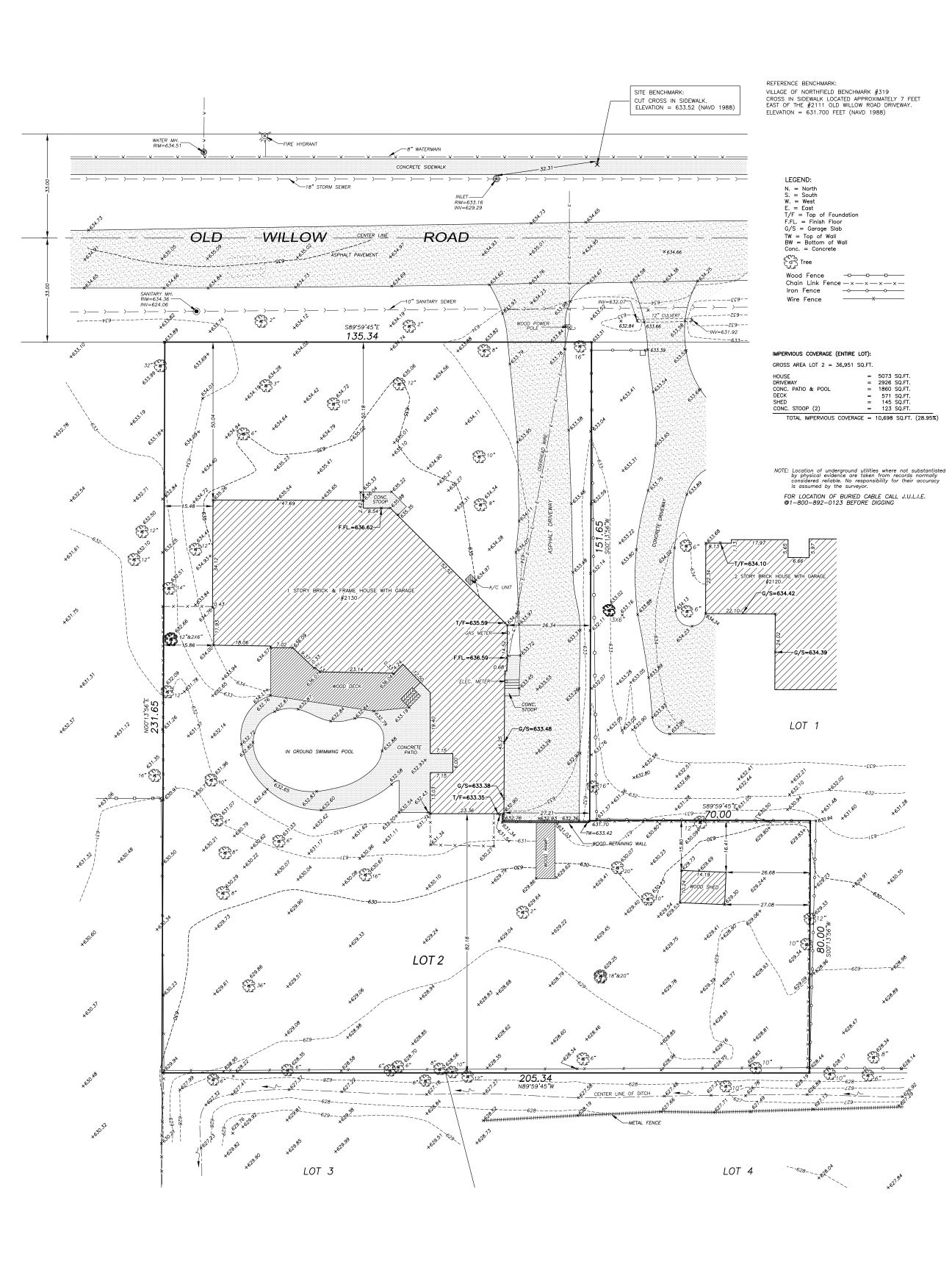
- The location, description, datum and elevation of all benchmarks to be used for the survey. The datum should be based on a nationally accepted datum whenever practical, unless instructed otherwise by the client or as mandated by a governmental organization having jurisdiction in the area the survey is located.
- The location and description of all horizontal control points to be used for the survey.
- If contour lines are required by the client, the contour interval should be agreed upon by the surveyor and client.
- Location and elevations of utilities is often an important part of a topographic survey. The surveyor and client must have a clear understanding of which utilities are to be located and what information on each utility is to be shown.
- The surveyor shall be furnished a clear, concise description of the intended use of the survey.
- Field Requirements.
- All surveying instruments shall be kept in proper adjustment and calibration.
- The surveyor may apply procedures that most efficiently meet the requirements of the client without sacrificing the accuracy of the acquired information.
- All field data, including electronic field notes, shall be retained in a legible and orderly fashion that will be understandable to other surveyors.
- Plats. On all topographic surveys, the completed plat shall be drawn on a stable and durable medium with a minimum size of 8½” by 11″ and shall contain the following:
- Firm name, address and registration number.
- Professional land surveyor seal, signature, date of signing, and license expiration date.
- “This professional service conforms to the current Illinois minimum standards for topographic surveys.” This statement shall be placed near the professional land surveyor seal and signature.
- Client’s name.
- North arrow.
- Date of completion of field work.
- Scale as agreed upon by surveyor and client.
- Location and elevation of benchmarks at or near the survey shall be shown, and the datum noted.
- Legend for all symbols and abbreviations used on the plat.
- If elevation points are to be shown, such elevations shall be shown to the nearest one-hundredth of a foot on hard surfaces and to the nearest tenth of a foot elsewhere, unless requested otherwise by the client.
- Description of horizontal control points used in the survey, which shall be noted and shall be shown on the plat if possible.
- The location of permanent structures, including buildings, retaining walls, bridges, culverts, street or road paving and sidewalks.
- Existing contour lines indicating the relief of the entire parcel, unless required otherwise by the client. Elevation points, if shown, may be in a grid pattern or at high points, low points and grade changes, a combination of both methods, or at locations requested by the client.
- Location and water surface elevations of lakes, rivers, streams and drainage courses on or near the surveyed parcel, and direction of flow if any.
- If boundary line information is shown on the plat, the source of the boundary line information.
- If topographic information is to be delivered via electronic media, a suitable format shall be agreed upon. In every case, the surveyor shall also provide a signed and sealed hard copy drawing or representation of the survey. This drawing shall be the official survey and shall be deemed to be correct and superior to the electronic data.