

History of Surveying
 Geodesy (/dʒiːˈɒdɨsi/),[1] also named geodetics, is the scientific discipline that deals with the measurement and representation of the Earth. (Source: Wikipedia)
In the 18th and 19th centuries the art of surveying advanced more rapidly. The need for maps and location of national boundaries caused England and France to make extensive surveys requiring accurate triangulation; thus geodetic surveying began. The U.S. Coast and Geodetic Survey was established by an act of Congress in 1807. Initially its charge was to perform hydrographic surveys and prepare nautical charts. Later its activities were expanded to include establishment of control monuments throughout the country.
Increased land values and the importance of exact boundaries, along with the demand for public improvements in the canal, turnpike, and railroad eras, bought surveing into a prominent position. More recently, the large volume of general construction, numerous land subdivisions with better records required, and demands posed by the fields of exploration and ecology have entailed an augmented surveying program. Surveying is still the sign of progress in the development and use of the earth’s resources.
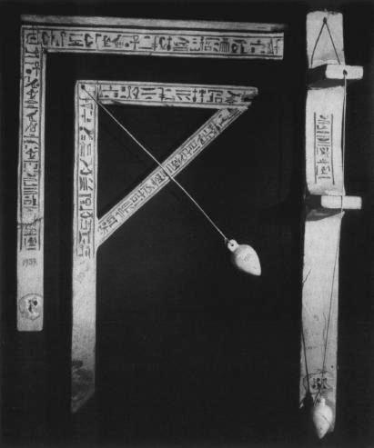
A plumb, a square, and a square level from the tomb of Senedjem
at Deir el-Medineh.
The Earliest Surveying Instruments
The observation that a heavy object hanging from a string causes the string to hang perpendicular to the earth is easily made.
This observation made the plumb bob the earliest surveying instrument.
By 2600 BC, we know the Egyptians had taken this concept and created the earliest surveying instruments: the plumb board, the A-Level, T-Level and plumb square. This was the first of the plumb bob, against a wood frame that paralleled the surface being measured. The worker could then make a more precise visual judgement as to the trueness of plumb horizontal level.

These earliest bobs were stone and their shape, although often egg-like, really didn’t matter. These simplest of tools remained virtually unchanged for the next 4400+ years.
The invention of the spirit level, and the beginnings of the Industrial Revolution that allowed the level to be manufactured, both accurately and cheaply, began the demise of the ancient plumb tools. For establishing plumb and true horizontal the level is simply a better tool. It is quicker and easier to use and just as accurate. But there is one thing the level can’t do easily, and that is to transfer an exact point from one height to another. The plumb bob is still an indispensable tool in modern construction.
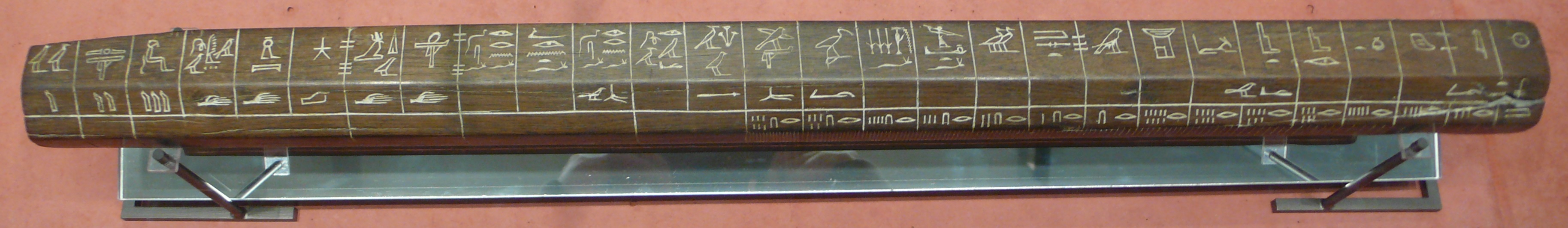
Egyptian measuring tool.
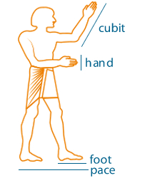 Early standards of length were based on body measurements. The cubit was the distance from elbow to finger tip, while the foot, palm and finger units are self-explanatory.
Among the earliest length measures was the foot, which understandably varied from district to district, and occurred in two common sizes. The first is the foot of 246 to 252 mm based on a man’s unshod foot. The second foot measures 330 to 335 mm and is based on hand measurements.
Other units derive from the Roman, Saxons, Angles and Jutes who each invaded England at some time. The rod, furlong and acre are all of Saxon origin. The mile is a compromise between the French derived Old British mile and the Roman milliarius.
- Link – 7.92 inches
- Fathom – 5.5 feet
- Rod/Perch – 3 fathoms or 16.5 feet
- Chain 66 feet
- Furlong or Furrowlong – 660 feet
- Mile – 5280 feet or 1760 yards
- League – 3.125 miles
The Magnetic Compass
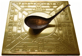 The magnetic compass is one of the most important instruments in the history of surveying. The compass was probably invented by the Chinese during the Quin dynasty (221-206 BC). Chinese fortune tellers used lodestones (a mineral composed of an iron oxide which aligns itself in a north-south direction) to construct their fortune telling boards.
Eventually someone noticed that the lodestones were better at pointing out real directions, leading to the first compasses. They designed the compass on a square slab which had markings for the cardinal points and the constellations. The pointing needle was a lodestone spoon-shaped device, with a handle that would always point south. Magnetized needles used as direction pointers instead of the spoon-shaped lodestones appeared in the 8th century AD,again in China, and between 850 and 1050 they seemed to have become common as navigational devices on ships. The first person recorded to have used the compass as a navigational aid was Zheng He (1371-1435), from the Yunnan province in China, who made seven ocean voyages between 1405 and 1433.
Colonial Surveying – Compass & Chain:
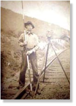
Old time surveyor with stadia rod transit and tape.
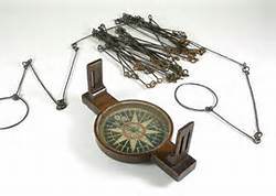 From colonial times, though the 1800’s, surveying in this country was performed using a crude transit or a compass and a “chain”. The most common surveyor’s chain was 66 feet long and made up of 100 links. 1 link is equal to 1/100 of a chain or 7.92 inches. These units of measurement can still be found in many older deeds on record at the courthouse. The modern steel and fiberglass measuring tapes used by surveyors are still referred to as “chains” in deference to these early methods of surveying. Other early units of measurement were called “rods” or “poles”, representing 16.5 feet for each unit. The compass was either mounted on a tripod or a single pole, called a “Jacob Staff”. These early surveying tools were not very precise, but were sufficient in the days when land values were 50 cents per acre, or less.
Eventually the use of the compass gave way to the transit, and the chain to the steel tape. While the compass was generally only able to measure the magnetic bearing of a line to the nearest one-quarter degree, a transit is able to measure the angles between lines to less than one minute of an arc. The steel tape, usually 100 or 200 feet long and graduated in hundredths of a foot, provided an accuracy significantly greater than the Gunter’s Chain. The transit and tape permitted more precise measurements necessary in land surveying.
Theodolite and Electronic Distance Measurement (EDM):
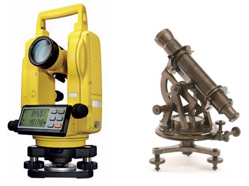
Modern vs Antique Theodolite
There are no exact standards differentiating an instrument referred to as a “Transit” from one that is referred to as a “Theodolite”. Generally, a theodolite is a much more precise instrument. Some can measure an angle to within 1/10 of one second of arc (one thousandth of a foot in one mile), but 1-second or 3-second theodolites are typical. Also, the angles on a transit were read off of a circular metal plate, graduated in degrees and minutes, while the theodolite replaced the metal plate with an internal etched glass plate and the ability to read an angle through the eyepiece via a series of mirrors and lenses.
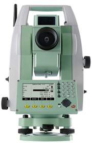
Modern surveying total station by TopconBy the 1970’s, relatively small, lightweight and easy-to-use electronic distance measuring devices, called EDM’s were in use. They were mounted on the theodolite, and operated on the principle of transmitting a narrow beam of infrared light to a reflector and measuring the time it takes to return.Before long, the advance of technology and miniaturization of electronic components enabled the building of theodolites that measure angles electronically, measure distances with their own internal EDM, and display a variety of data on an LCD screen. These super-theodolites are referred to as “Electronic Total Stations”. In addition to enhanced speed and accuracy, the digital data can be automatically “downloaded” to an electronic data collector for transfer directly to computers for calculations or CAD drafting. In addition to the speed and accuracy that they provide, the decreasing cost of the electronic total stations has allowed them to virtually totally replace all previous methods and instruments for most survey work. Modern Total Station Pictured at right
GPS – Global Positioning System
The GPS satellite system (also known as NAVSTAR) was developed by the Department of Defense for obvious reasons. There is presently a nominal operating constellation of 24 satellites. The satellite signals received by the general public are intentionally degraded by the DOD. The system was never meant for civilian use. Some really smart guys figured out a way to use the GPS carrier signal to calculate a receiver’s position on the earth in spite of the encryption. This is made possible through the use of two receivers and extremely accurate clocks, used to time the signals received from the satellite vehicles (SV’s). The ready availability of these precise clocks make GPS possible. It is now possible to calculate 3 dimensional positions using these receivers at virtually any point on the earth.GPS does have it’s limitations though. The receivers are very expensive, although the price is gradually coming down. And the receivers must have a relatively unobstructed view of the sky. This means that the system is useless indoors, under tree canopies, or in canyon-like locations. Neither can the receivers be used close to buildings or vertical surfaces due to an effect called multipath. Multipath simply means that a receiver gets 2 signals instead of one, due to the reflective properties of a vertical surface. Lastly, the available satellites must be in good geometric formation across the sky. If the satellites are “bunched up” near a single location, the data collected will not give adequate results.Professional Land Systems utilizes GPS for projects that, in our judgment, are appropriate candidates for the technology. Cellular tower sites are a good example. The FAA must know the exact location and height of all towers, for purposes of air traffic navigation. GPS is the perfect candidate for such an application. GPS is likewise useful for site that have been cleared of most trees. Real Time Kinematic (RTK) GPS is very useful for construction sites or shopping center ‘as-builts.’
Robotic Surveying Systems
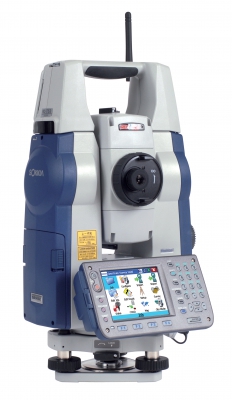 Robotic “one man” surveying systems are now readily available. These are total stations that are remotely controlled by the use of radios and servo-motors. This is a relatively new and expensive technology to implement, though many surveying companies find that, compared to adding personnel, automated technology is more economical. A robotic surveying system costs in the range of 30-35,000 dollars. [Update: This article was written about five years ago. The cost of robotic technology has decreased substantially and now costs about $25,000 as of 2012.] The first robotic total station was made by a company called Geodometer (now known as Trimble Navigation) in 1990. PLS purchased a Topcon Robotic system in 2006.